


Tropical Storm Chantal Hits South Carolina: Brace Yourself for Floods and Tornadoes!
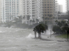
South Carolina just got an unwelcome visitor – Tropical Storm Chantal, which made landfall early this morning and is already causing chaos. Winds are blowing at 80 km/h, and the storm is moving inland at about 13 km/h. This isn’t just some rain – meteorologists warn of heavy rainfall that could trigger flash floods, and local authorities have already issued warnings for possible isolated tornadoes along the coast.
Where is Chantal now? At 5 a.m., the storm’s center was about 80 kilometers east of Charleston and 50 kilometers southwest of Wilmington, North Carolina. The storm is expected to move further inland through South Carolina and then North Carolina, weakening as it hits land.
Why does this matter? The Atlantic hurricane season runs from June 1 to November 30, with peak activity usually between mid-August and mid-October. Still, Chantal has already shown it can cause serious trouble. South Carolina’s emergency department has warned residents to be ready for possible floods and tornadoes, which is not something to take lightly.
What’s coming? Chantal is expected to bring heavy rains that could cause flash floods in coastal plains. This means many could be trapped in their homes or on the roads. If you’re in South or North Carolina, now’s the time to check your supplies, secure your windows, and prepare for possible outages.
Bottom line? This tropical storm isn’t just another weather event – it’s a wake-up call that hurricane season is in full swing and nature can surprise us anytime. Got a story or experience with Chantal or other storms? Drop a comment below – let’s see who’s ready and who’s gonna be caught off guard!
Slug: tropical-storm-chantal-south-carolina-floods-tornadoes